Red Lining and Blind Stitching in the Fabric of Greater Boston
An Installation by Caroline Rufo
“Intervisible” is a term used in urban planning. It refers to the state of being mutually visible from specific positions in the landscape.
The history of the development of suburbs around American cities is the history of how racial segregation was maintained after the Civil War and during the Great Migration. It is the story of how the financial and municipal resources of the 20th century were purposely directed to white people and away from people of color.
The fabric, paper, thread and string used to make up this artwork are all 100% cotton.
This history remains invisible to many white people. It takes effort to see and believe the way white suburban prosperity and black urban neighborhood degradation was caused by a combination of real estate practices such as “blockbusting”, racial covenants designed to keep people of color out of white neighborhoods, the redirecting of government resources out of the cities and into the suburbs, and of redlining.
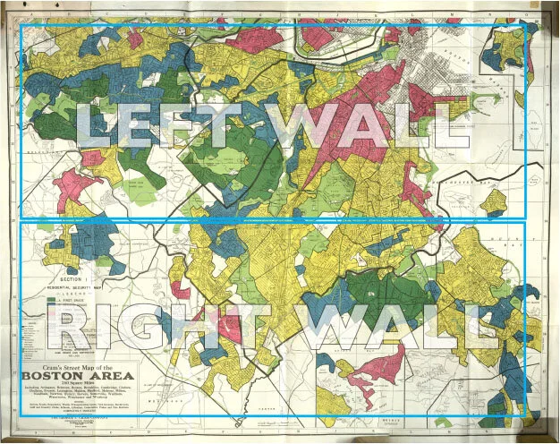
The design of the outer fabric walls of this piece are taken from the Home Owners’ Loan Corporation “Redline” map of Greater Boston. These walls are made from hand-dyed cotton batting, a fabric usually used to line the inside of quilts.
This piece explores the ways I am encouraged as a married suburban cis-hetro-white woman to direct my gaze on my home, the town where I live, the rearing and education of my children, and my “personal growth”; rather than on the structures that maintain our system of white supremacy. Complacency results in blindness and continued injustice. It leads to the dangerous myth of the “self-made man”, which can only exist inside a vacuum of white historical mythology. It leads us away from true intervisibility.
The inner walls of this piece are designed to interrupt the viewer’s ability to see the maps. The images cut into these screens include, cotton plants, college pennants, Battenberg lace, chain link fence, and houses.
I would like to acknowledge that all of the land referred to in this artwork, as well as the land where this gallery stands, is the traditional hunting grounds, fishing grounds and home of the Massachusett peoples.
And, I would like to note that the land did not consent to becoming an instrument of oppression.
Above is an image of the HOLC redline map of Boston. In the installation, I translated the two boxed areas into fabric walls.
Below are process images. Left to right, top to bottom: Detail of a model of the Installation, sample of cotton Battenberg Lace, pieces of hand dyed cotton batting being reassembled into the map walls, one panel of laser cut watercolor paper over the stitched fabric map, an image from a day of research at Lowell Mills, Drawing of a cotton plant, cotton samples from the RISD Nature Lab, Hand dyed fabric for the maps drying, sketch of the gallery space, hanging lace panels, process shots from a photo shoot of some elements of the installation. (Thank you to Matt Kedzierski for support and labor on this project!)


